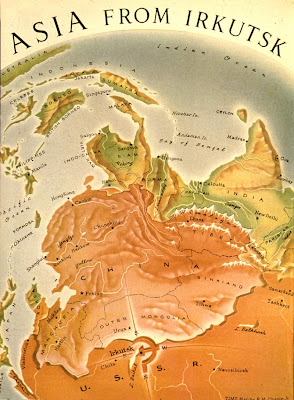
Strange Maps has uncovered this awesome Time Magazine map from 1952 showing the Communist wave emanating from Irkutsk out into Asia. Interesting to note it uses the old name for Urumqi, Tihwa. It’s interesting to see that the American public was being told that Mongolia was incorporated into China in 1952, even though both countries recognized one another’s legitimacy in 1949. Mongolia was a Soviet satellite, not a Chinese one, but considering the maps perspective declares China one as well, I guess that’s not such a big matter. Just eight years later the Sino-Soviet split, slowly building during the late 50s, would become a public spat, and in 1962 the Soviets would support India against China and Mao would call Khrushchev a wussy for backing down in Cuba. In 1969, the USSR and China would fight border skirmishes while the Cultural Revolution condemned the Soviets.
Meanwhile, “Domino Theory” continued to be popular in successive White House administrations. This map would not have been out of place in 1969 if Time had chosen to rerun it.
If you look at the border demarcations, you can see that Mongolia is depicted as a separate country (dotted line) and not as a province of the PRC (dashed line), altho the similiar coloring does make it confusing.